Topic 12 - Information displayed on the fish finder screen
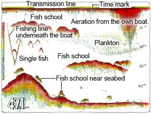
Lets have a look at what kind of information gets displayed on a fish finder screen. The image below shows a typical fish finder screen. A fish finder screen usually displays the sea level, sea bottom and fish schools in between. Based on the data received by the fish finder and the fish finder's settings, display of the sea level, sea bottom and fish schools will vary in shape, concentration, hue and distribution.
First of all, at the very top of the graph we see the minute marker, a thin yellow line. This yellow line combined with the empty line following it represents exactly one minute.
Right below the minute marker we find the transmission line. The transmission line corresponds roughly with the sea level, so it can henceforth be considered as the sea level. Strictly speaking, it denotes the position of transducer transmitting ultrasonic pulse waves mounted on the underside of the boat. The transmission line varies in size depending on which type of transducer is used and what frequency the transducer is transmitting at. When the line is thick, there is a risk that it might overlap fish schools close to the sea level, making them hard to distinguish.
Below the transmission line is the water column, where fish schools swimming around can be seen. When fish schools are detected by the fish finder, they can be displayed in a variety of ways; like lumpy clouds, mountain or round shaped formations, or as sporadic dots. One handy feature of the fish finder is the ability to distinguish between normal protrusions on the seabed and fish schools grouped close to the seabed. It is also possible to determine the location of fishing lines hanging from your own boat, as show on the left side of the illustration.
Close to the sea level on the right side of the illustration, we can see plankton and what air bubbles (aeration) from the propeller looks like on the fish finder screen.
Fish finders can also display the distance to seabed, range scale, ultrasonic pulse wave frequency, A-scope mode and much more. Depending on the type of fish finder, there are also functions that allow for GPS positioning, providing longitude and latitude data of the own boat on screen.