- Multi-Purpose Display
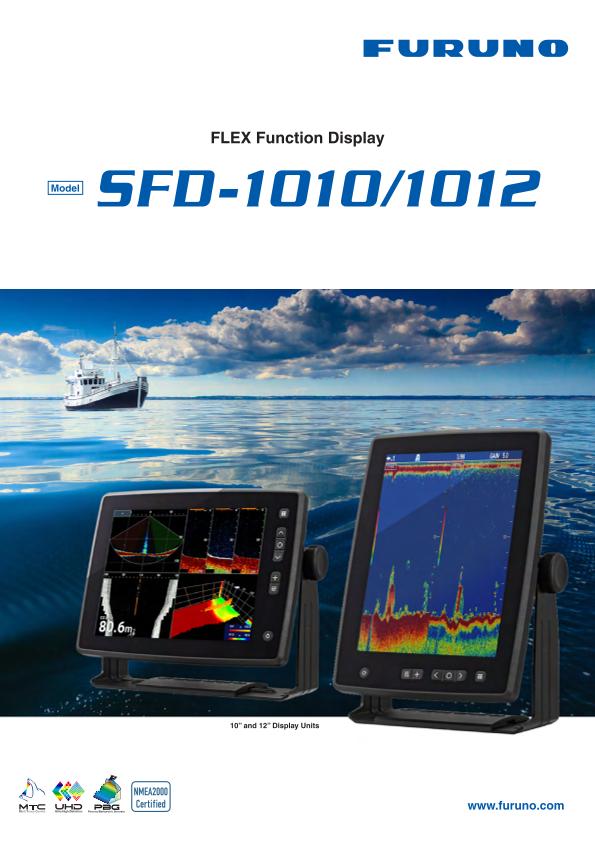
Model SFD-1010/1012
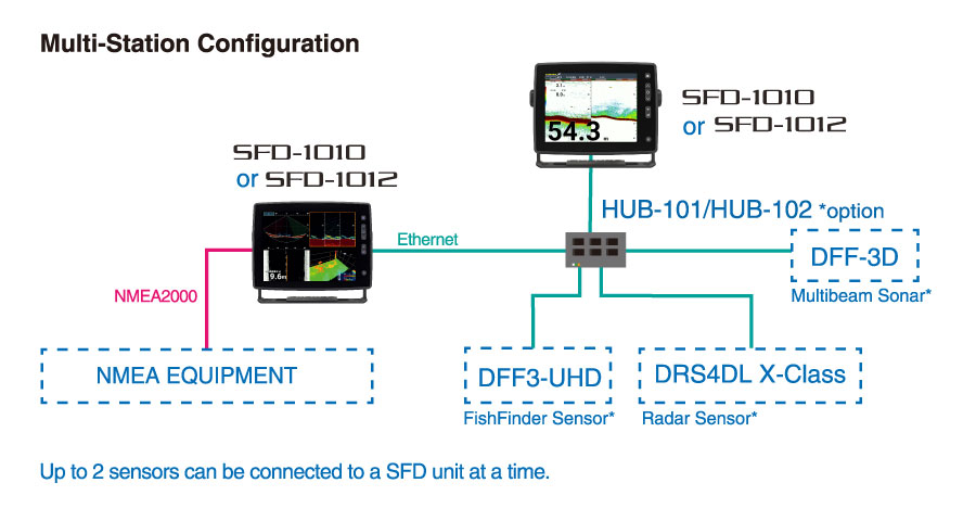
Discover the SFD-1010/1012, 10" and 12" display and control units compatible with a wide range of Furuno sensors from DRS4DL X-Class Radar to DFF-3D Multibeam Sonar or Fish Finders. These are versatile and highly adaptable Display units that, combined with a hub and your favorite sensors, allow multiple configurations to suit all needs, from recreational boating to workboats.
- Fishing Vessels、Workboats、Recreational Boats
Features
Designed to work with our most popular sensors
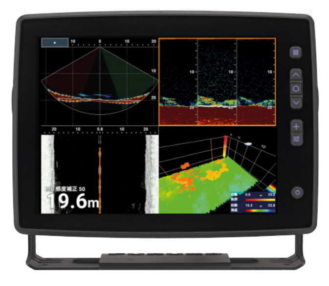
SFD-1010/1012 has been designed to work with our most popular sensors such as Radar, Fish Finder and DFF-3D. Each display unit will therefore be able to display the desired mode depending on the configuration.
Multibeam Sonar
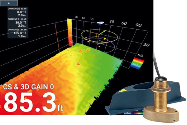
Connect our popular DFF-3D Multibeam Sonar which displays echoes in high-resolution and gives you access to several useful modes such as Cross Section, 3D history, Triple Beam, or Side-Scan.
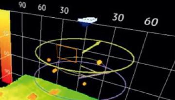
Thanks to a virtual fishing net, you will be able to determine the position of the net's mouth in relation to the targeted school of fish and thus increase the efficiency of your catch. In addition, you can overlay sea current information as shown in the picture.
- To display current information, Furuno’s CI series must be connected.
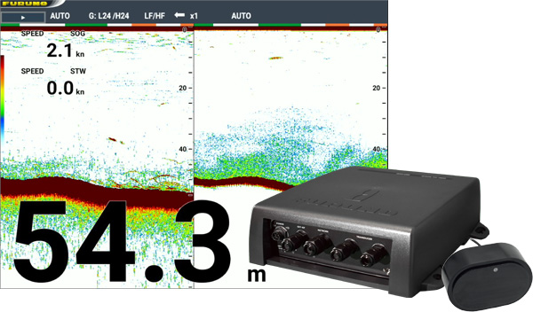
Fish Finder
Connect our powerful Fish Finder DFF3-UHD and enjoy our best fishing technologies such as TruEcho CHIRP™ and ACCU-FISH™.
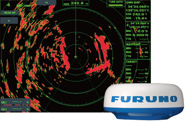
Radar
Connect our Plug-and-Play Radar to ensure your safety at sea with the extremely compact Radome 19" DRS4DL X-CLass* which features Fast Target Tracking™ and requires only one LAN cable and one Power Supply cable for its installation.
The Multi-station feature allows you to connect two SFD displays to one Radar. We recommend the vertical orientation when using Off-center. it is perfect for Workboats.
- The DRS4DL X-Class does not comply with RED, UKCA or ISED regulations.
Flexible orientation for your favorite display mode
Touch Control + Control Keys

The SFD is also very flexible in its control capabilities, ranging from multi-touch to control keys, as well as operation with an optional mouse.
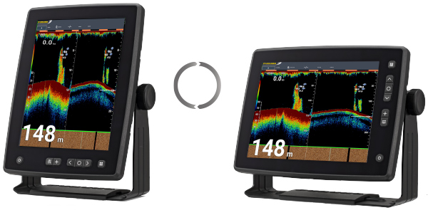
* Adjustable bracket to fit your preferred display orientation.
Bathymetric shaded relief maps
Quickly create your own PBG (Personal Bathymetric Generator) Shaded Relief Maps using SFD and the DFF-3D or Fish Finders. Bottom images are drawn with shaded relief, depth contours, and variable colors, making it easy to identify hidden structure and ridges that hold fish in a simple,easy-to-interpret presentation.
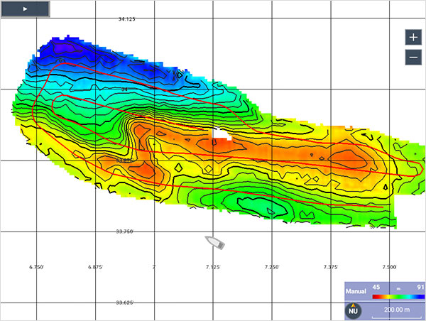
PBG created with Multibeam Sonar
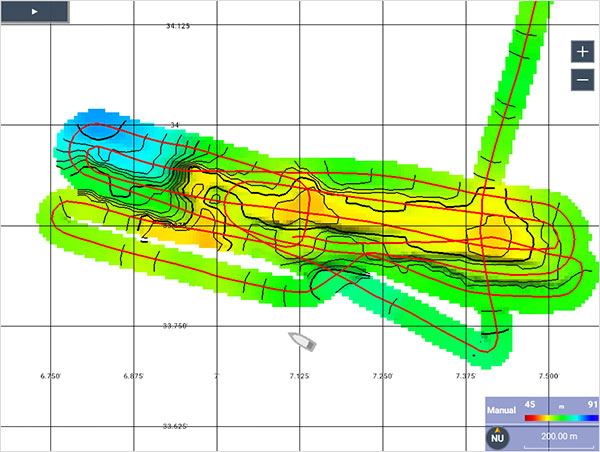
PBG created with Fish Finder (Single beam)
PBG compatible Furuno’s Fish Finder
Model | Interface | |
FCV Series | FCV-38, FCV-2100, FCV-1900/B/G, FCV-295/1150, FCV-585/620, FCV-588/627, FCV-688 | NMEA0183 |
FCV-600/800 | NMEA0183/2000 | |
Chart plotter with F/F | GP-3700F, GP-1871F/1971F | NMEA0183/2000 |
DFF Series | DFF3-UHD, DFF3 | Ethernet |
NavNet TZtouch Series | TZtouchXL, TZtouch3, TZT2BB | Ethernet |
- The above diagram shows almost the same area mapped with each beam. The red line is your ship's wake. A single beam only provides information directly below your ship, whereas a multibeam detects a 120° width to the left and right, making multibeam more efficient at creating seabed maps.
When using the seabed mapping function with a single beam, it is not possible to display fish finder echoes. - Recommend connecting a satellite compass as it reduces the effects of wave swaying.
- Chart overlay is not possible.
Sub-monitor function with NavNet TZtouch Series
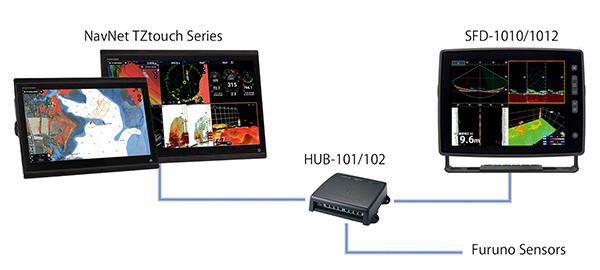
By connecting to the same network as the NavNet TZtouch series, it is possible to display and operate sensor information within the network. The NavNet TZtouch series displays a variety of navigation information, and the SFD allows you to check and operate Fish Finder/Radar/Multibeam Sonar information on a large screen, making it convenient.
Specifications
General
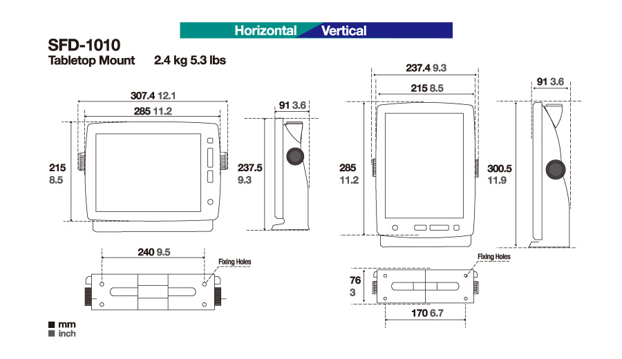
SFD-1010: 10.4” TFT COLOR LCD
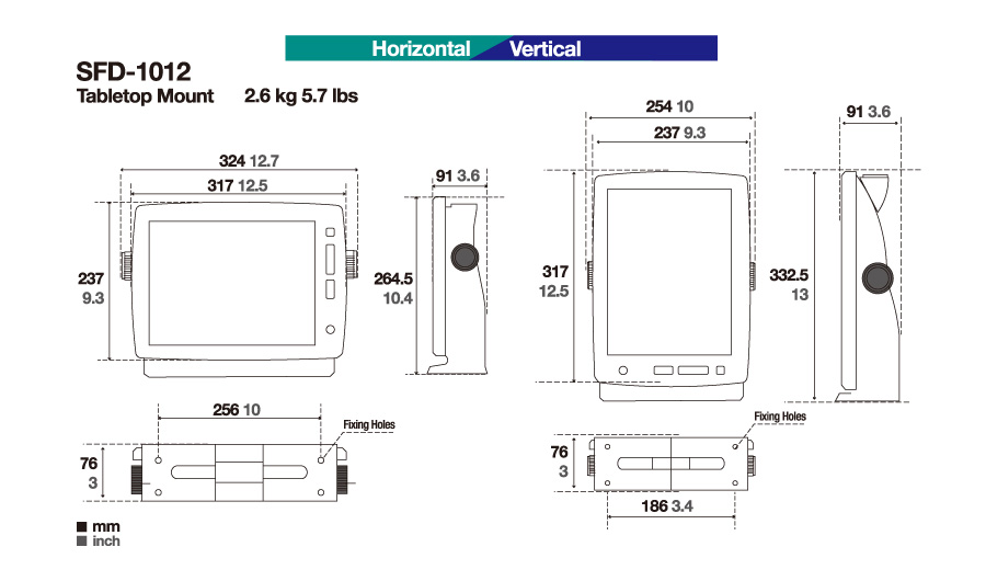
SFD-1012: 12.1” TFT COLOR LCD
SFD-1010: 1024x768 (XGA)
SFD-1012: 1024x768 (XGA)
80° (minimum)
800 cd/m²
Serial: 2 ports, NMEA0183
LAN: 1 port, Ethernet 100Base-TX, RJ45
USB: 1 port, USB2.0 (Type A), For maintenance
NMEA2000: 1 port
HDMI Output: 1 port, 1280 x 720 (HD)
Data sentence
Input: GGA, GNS, HDG, HDT, MDA. MWV, RMA, RMB, RMC, THS, TLL, VHW, VTG, WPT, ZDA
Output: TLL
−15 ℃ to +55 ℃
IP25
12-24 VDC, 3.0 - 1.5 A
SFD-1010: 2.4 kg 5.3 lbs
SFD-1012: 2.6 kg 5.7 lbs
Drawing
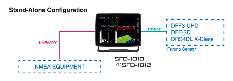
Interconnection Diagram
Downloads
| Name | Last update |
|---|---|
| Aug 6, 2025 | |
| Aug 6, 2025 |
| Name | Remarks |
|---|---|
|
|
Distributors of Marine Equipment
Contact a local distributor for further details.
- Specifications subject to change without notice.
Multi-Purpose Display Product List
Model
MU-152HD/192HD
Model
MU-152
Model
MU-192
Model
MU-190
Model
MU-190V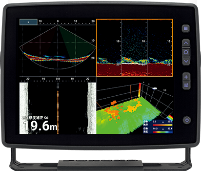
Model
SFD-1010/1012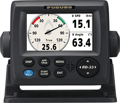
Model
RD-33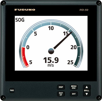
Model
RD-20/50