The Observation Network Created by the Earthquake Proves Useful for Accurate Timekeeping (Part One of Two)

Jun 20, 2025
Have you ever had that chilling moment when you noticed the clock you glanced at while getting ready in the morning was significantly behind the others? Are all the wall and desk clocks in your home ticking in sync? Each clock may run fast or slow at different rates, and keeping them all perfectly synchronized—especially with varying battery replacement times—is quite a challenge.
If you visit the clock section in an electronics store, you'll see clocks showing different times. The exception is radio-controlled clocks. Those clocks, which receive JJY (Japan Standard Time radio signal) broadcast by NICT from Fukushima and Saga should show perfectly synchronized movements down to the second hand.
In the world of GNSS, atomic clocks onboard satellites are synchronized with master clocks at control centers, ticking in unison. This is the fundamental premise of satellite positioning. However, the idea that "each positioning satellite automatically adjusts its time like a radio-controlled clock based on commands from the control center" is an oversimplification.
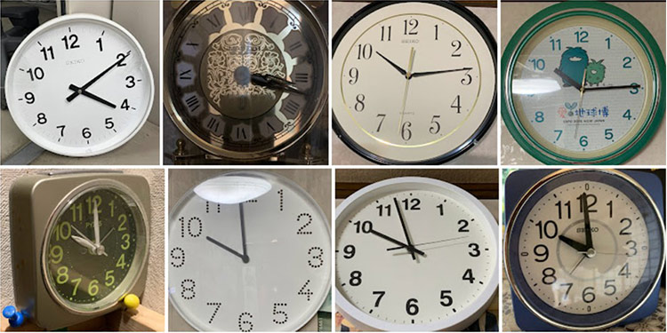
From an analog clock in the author's possession
Let me introduce a perfect story that illustrates the difficulty of synchronizing the clocks of orbiting positioning satellites. It's one of the most famous works by British picture book author Pat Hutchins, titled Clocks and More Clocks.
In the story, Mr. Higgins found an old clock in his attic. It worked fine. And at first, he was pleased. But soon, he began to worry whether it was showing the correct time. He bought a new clock and placed it in the downstairs bedroom to compare, but the times were slightly different. So, he placed new clocks in the kitchen, the hallway, and other rooms. Each time he checked them, they all showed slightly different times. Mr. Higgins became quite confused... and that's the story.

Source: "Clocks and more Clocks" (Authored by Pat Hutchins / Translated by Nobuhiko Tanaka, Published by Horupu Publishing, First edition in 1976, Reprinted edition in 2006)
The many clocks Mr. Higgins placed in different rooms can be likened to satellites orbiting the Earth. The distance to satellites is far beyond our everyday sense of scale, and the time intervals involved are much smaller, requiring special consideration for synchronization*. One key factor is "propagation delay"—similar to the time it takes Mr. Higgins to walk up the stairs to check another clock.
To accurately determine propagation time, you must know the exact distance (position). For that, you need precise orbital data and accurate time. But to obtain those, you again need accurate distance information to the satellite. As you can see, it's a circular problem.
If you're not careful, you might end up calculating distance based on a clock whose accuracy is uncertain, and then use that distance to synchronize time—falling into the same dilemma as Mr. Higgins.
To avoid this, a different perspective and tools are needed. In the picture book, it was the watchmaker's pocket watch that solved the problem. In satellite positioning, the solution comes from "GNSS continuous observation stations" placed around the Earth—also known as electronic reference points, as introduced in Part 1.
Originally, satellite positioning is based on receiving signals from multiple (at least four) satellites and analyzing them to determine one’s own position and time. By reversing this process—collecting and analyzing data from numerous observation stations on Earth—we can accurately determine the satellite’s three-dimensional position and time.
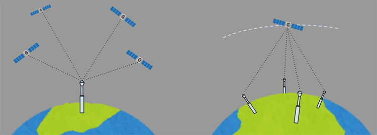
Basic principles of satellite positioning (left) and the concept of satellite orbit estimation (right). In practice, in addition to positioning signals, a method called SLR (Satellite Laser Ranging) is also used, which estimates the distance between the ground and the satellite based on the round-trip time of laser light.
Japan’s GNSS, the Quasi-Zenith Satellite System "Michibiki", operates with eight control stations: a main station in Ibaraki, a substation in Kobe, and six tracking control stations. In addition, 13 domestic and 23 overseas monitoring stations (GNSS continuous observation stations) are deployed to continuously monitor positioning signals. A document called the Performance Standard (PS) publicly states the guaranteed accuracy, indicating that the error in distance to the satellite is "±2.6 meters > 95%."
(Reference: https://www.soumu.go.jp/main_content/000800171.pdf)
Similarly, GPS also publishes accuracy figures within a few meters as a kind of "promise" to users. Of course, efforts to improve accuracy continue daily. On the other hand, if we look at the actual past orbits of satellites, the accuracy can be even higher. This is where the globally distributed "electronic reference points" (or GNSS continuous observations) come into play. An organization called IGS (International GNSS Service) serves as a platform for these reference points operated by national agencies around the world, collecting and integrating observation data.
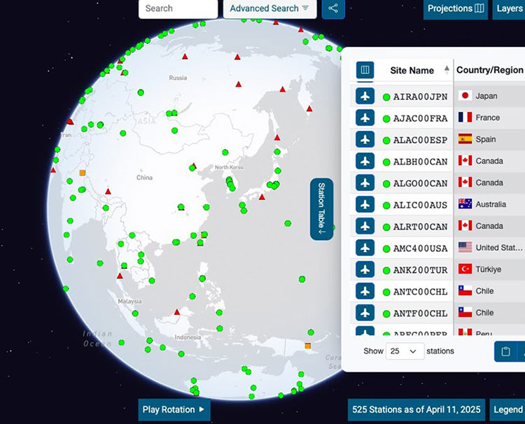
Source: IGS (International GNSS Service)
https://igs.org/network-resources/
Over 500 observation points that have been stably operated are registered, and 13 independent organizations—including national agencies and universities from various countries—analyze the data using their own methods to estimate satellite orbits. Japan joined this initiative in 2023, with JAXA and the Geospatial Information Authority of Japan collaborating on the analysis.
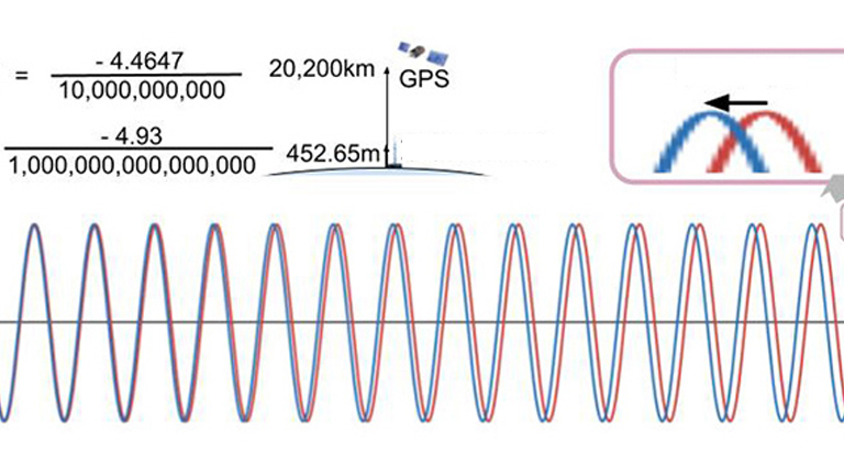
These results are averaged with weighted values, and the final satellite orbit data is published about two weeks later. The accuracy of this data, known as the IGS Final Ephemeris, is ±2.5 cm. That means the distance to satellites flying about 20,000 km above the Earth is determined with an error of less than 2.5 cm.
Such high-precision orbital data not only serves as a foundation for geodesy and various academic research fields, but also plays an essential role in expanding human activity to the Moon and beyond.
Interpreting this level of accuracy from the perspective of "time synchronization," GNSS already has the potential to provide precise time across the entire globe at the picosecond level. Mr. Higgins would no longer have any trouble.
I would like to introduce how this highly accurate time synchronization infrastructure is being utilized and applied in various fields in a future article.
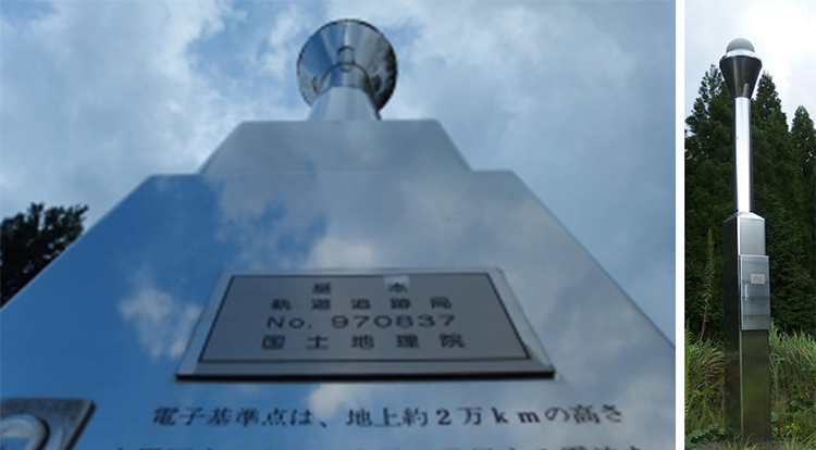
Photo: The electronic reference point "Aira: 970837" belongs to the category of “orbit tracking stations,” which once had a VLBI antenna installed. It is also operated as an IGS observation point (AIRA00JPN), and its radome shape differs slightly from other electronic reference points.

Born in Ishikawa Prefecture in 1964. Based on his experience in covering industrial technology, cutting-edge technology, and space development, he is passionate about unraveling and conveying difficult topics in an interesting way to people of all ages, from children to senior citizens. From 2009 to 2014, he was a member of the editorial board of "JAXA's," the official magazine of the Japan Aerospace Exploration Agency. Author and co-author of the following books: 『あなたにもミエル化? ~世間のなりたちを工学の視点から~』(幻冬舎mc)、『私たちの「はやぶさ」その時管制室で、彼らは何を思い、どう動いたか』(毎日新聞社)、『東京大学第二工学部70周年記念誌 工学の曙を支えた技術者達』(東京大学生産技術研究所) etc.,

_1.jpg)
_1.jpg)
_1.jpg)
_1.jpg)
_1.jpg)