

Beyond Reality
FURUNO ENVISION AR Navigation System is our all-new advanced augmented reality navigation system that provides substantial support to navigation, using the power of AR to go beyond reality.
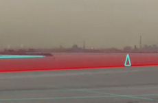
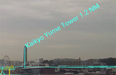
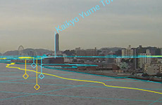
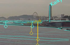
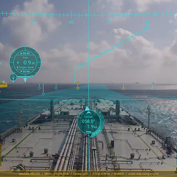
Thanks to a camera pointed forward of the vessel, an image of the front view projects on a display and all the necessary navigation information is superimposed over this live video imagery by our AR technology. Even in adverse weather or visibility conditions, you can clearly view other vessels' routes and critical information, as well as own ship data, allowing you stress-free maneuvering and navigation. This very intuitive way to display and share the information between the captain and the bridge team provides enhanced situational awareness, crew confidence, watchman support, and allows for better coordination of crew members.
The FURUNO ENVISION series aims to contribute to the safety and security of the voyage by offering visual support to maneuvering and navigation during any operation, a further technological step towards autonomous navigation.
- AR navigation is an auxiliary tool designed to improve the navigation comfort for safer navigation. In no case should AR navigation replace Radar, ECDIS etc. and other required instruments for danger avoidance.
Video
AR overlay
Thanks to a camera pointed forward of the vessel, an image of the front view projects on a display and all the necessary navigation information is superimposed over this live video imagery by FURUNO AR technology.
- Azimuth
- AIS
- Heading
- Radar Target Tracking (TT)
- Route
- Waypoint
- User chart & ENC symbols*
- UKHO® ADP current and tide display (option)*
- Connect to ECDIS is required.
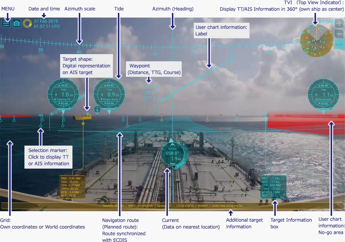
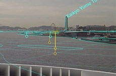
TVI (Top View Indicator)
Displays other ships by either Target Tracking (TT) or AIS in 360 degrees with own ship as center.
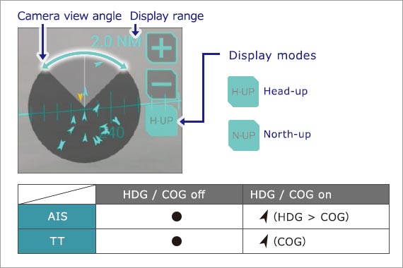
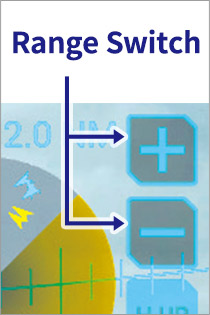
One-click range switching
In congested sea areas with a large number of vessels, it is possible to reduce the number of targets that are displayed by simply changing the range. This function is also very useful for temporarily checking distant targets.
Intuitive color-coded display for targets *
Based on CPA/TCPA value, TT and AIS targets will be displayed in different colors according to their threat level.
- TVI
- Selective marker
- Main target information frame
- Appended target information frame
- Target shape
- Colors adjustable (Yellow, Orange and Red are available)
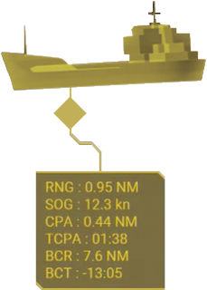
Selection marker and Target information box
Other ship information are collected by either TT or AIS are indicated with specific marks. When a mark is clicked, a box containing the information will open.
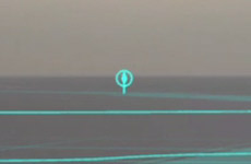
Target shape
By superimposing the graphical virtual shape over AIS targets (virtual buoy, buoy, boat, tanker), it becomes easy to visually grasp the location of dangerous targets and their directions.
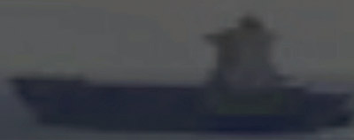
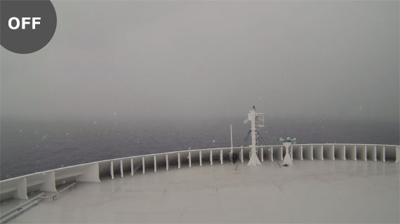
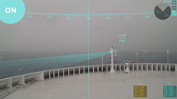
Target shape OFF
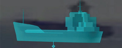
Target shape ON
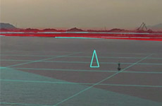
User can show/hide the information
User can show/hide the information (course to the next waypoint, time to go, distance) for the To way-point on the route.
No-go area
Landmark
Waypoint information
Pilot station
Buoy
Safety contour
Coastline
360° View (option)
- NEW
Marine Camera Unit Model AR-2001 for AR Navigation System
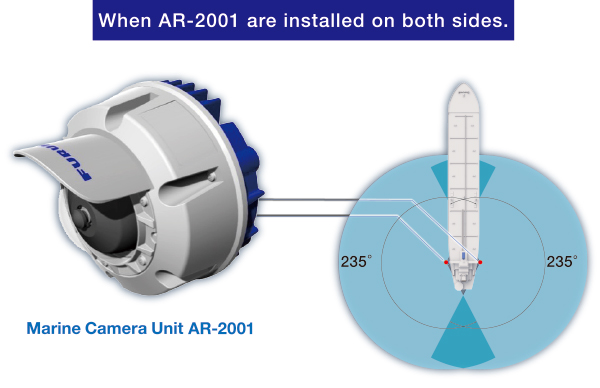
AR-2001 is the Marine Camera Unit (for outdoor use), which meets with the marine grade environment standard and can display 360° images of your ship.The camera features a "wide viewing angle" and "durable weather resistance", and by installing one in both starboard and port sides of your ship, you can instantly grasp the surrounding information necessary for the ship maneuverings.
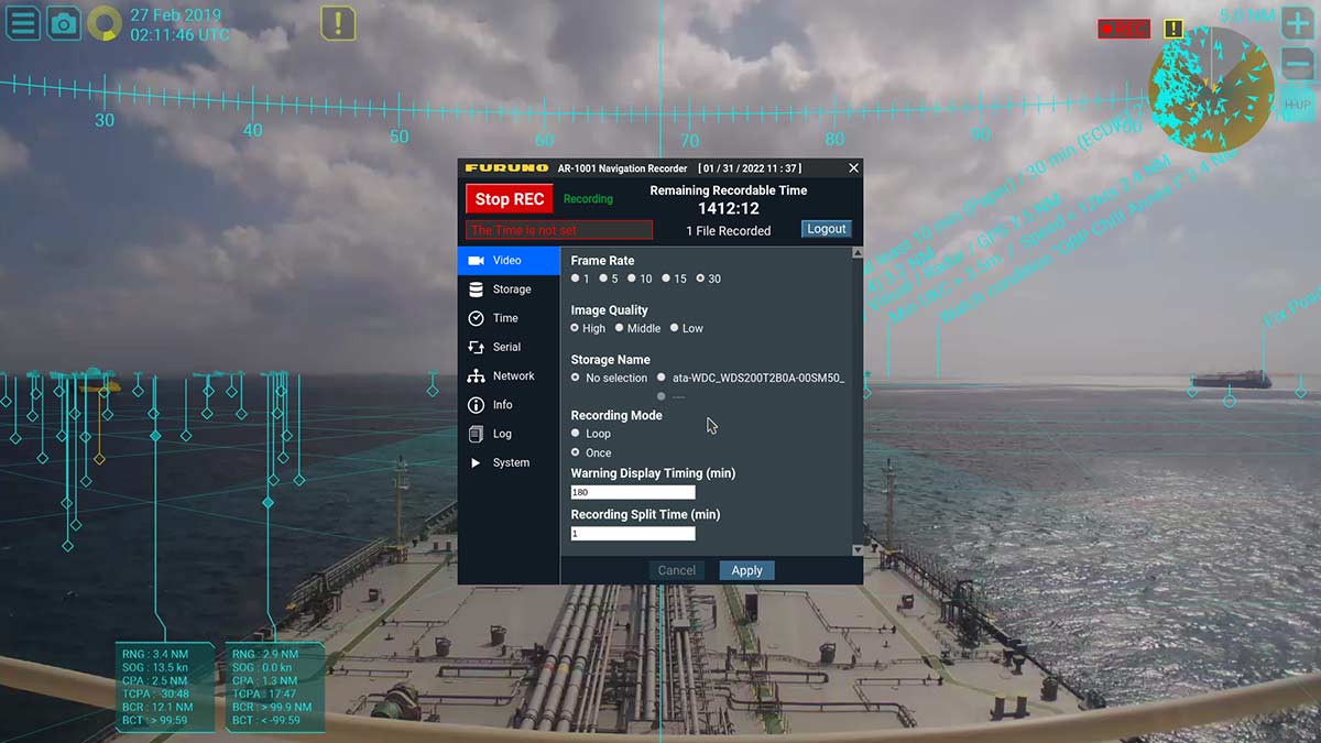
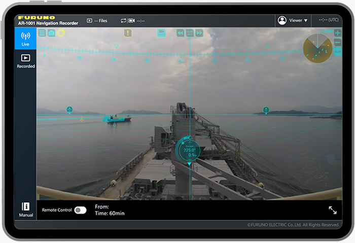
Navigation Recprder (option)
By recording navigation data to an external USB device*, events during an accident at sea can be analyzed and used as training materials for the crew.
- Customer supply
Web application function
You can display live images and play back recorded video by connecting a recommended tablet*1 via wireless LAN, and remotely control the camera using a dedicated viewer*2.
- iPad: 9th generation (iPad OS 17.3) or later, recommended for Safari. Customer arrangement.
- AR-100M only
Connectable products
Category | MODEL | Output port*1 |
AR Navigation System*2 | AR-100M | HDMI |
ECDIS | FMD-3100, FMD-3200 | DVI |
Fish Finder | FCV-1900, FCV-2100, FCV-38, FSS-3BB | HDMI |
Sonar | CSH-10, CH-500, CH-600, FSV-25 MARK-2, FSV-85 MARK-2, FSV-75 | HDMI |
Multi-Purpose Display | SFD-1010, SFD-1012 | HDMI |
Multi Function Display | TZT12F, TZT16F, TZT19F, TZT-10X, TZT-13X, TZT-16X, TZT-22X, TZT-24X, TZT-BBX | HDMI |
Radar | FAR-1416, FAR-1426, FAR-1513-BB, FAR-1523-BB, FAR-1518-BB, FAR-1528-BB, FAR-2018-MARK-2, FAR-2028-MARK-2, FAR-2228-NXT-BB, FAR-2238S-BB, FAR-2238S-NXT-BB, FAR-2258-BB, FAR-2268DS, FAR-3220-NXT-BB | DVI |
FR-10, FR-12 | HDMI |
- For DVI output, an HDMI-DVI conversion cable is required.
- Only the AR-100M can be remotely controlled via the web application.
What the eye cannot see
AR information overlaying the screen is particularly useful in poor visibility conditions.
AR Navigation ON/OFF Comparison in bad weather conditions
AR Navigation ON/OFF Comparison during nighttime navigation

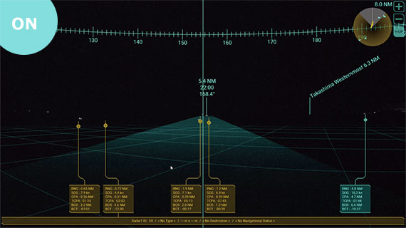
- By using a surveillance video camera and overlaying AR information on the display, our AR Navigation system allows for quick and intuitive situational awareness.
Stable AR expression
Even when the ship is pitching or rolling, the overlaying AR information remains stable and will not drift away from the real elements of the live imagery, providing reliable data in all circumstances.
Specifications
PRODUCT NAME
AR Navigation System
MODEL NAME
AR-100M
Processor
CPU
Intel® Celeron® N3350 2.4 GHZ
Memory
4 GB
Display mode
Target Tracking (TT), AIS, Azimuth, User chart, ENC chart symbol
Interface
Ethernet: 2 ports
RS-232: 1 port
USB USB2.0: 4 ports, USB3.0: 2 ports
HDMI: 1 port
Power Supply
100-240 VAC: 0.9-0.4 A, 1 phase, 50-60 Hz
Data sentences (IEC61162-1/2)
Input: GGA, GNS, HDT, OSD, RMB, THS, TLB, TTD, TTM, VDM, VDO, VTG, ZDA
IP Camera (Visible light camera for indoor use)
Resolution
1920 x 1080
Frame rate
25 fps
Video Compression
H.264 codec
Source
PoE Adapter
Marine Camera Unit (option)
Resolution
2000 x 1944
Frame rate
15 fps
Video compression
H.264
Power Supply
Powerd by PoE Power Sourcing Equipment
Navigation Recorder (option)
Recording data format
mp4*/jpeg
* Audio data not available
Recording duration
Depending on the available size of the storage device, 2 TB can store up to 720 hours of data.
PoE Power Sourcing Equipment (For Marine camera Unit/Customer arrangemant)
Power Supply
100-240 VAC: 0.2-0.08 A, 1 phase, 50/60 Hz
Monitor (option)
Resolution
1920 x 1080
Standard Equipment list
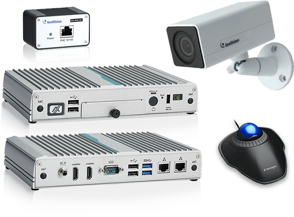
- Processor
- IP Camera(Visible light camera)
- PoE Adapter
- Trackball mouse
- ENC dongle*
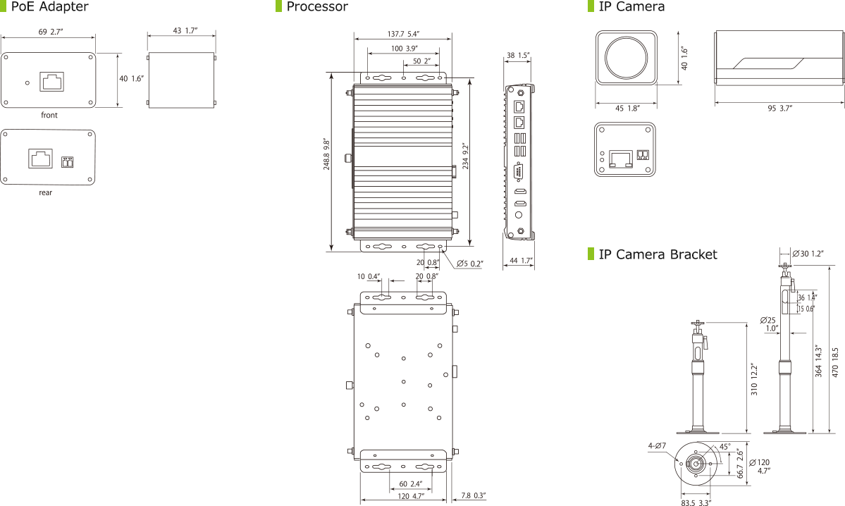
- Installation materials (HDMI cable 5 m, LAN cable 10 m x2 /2 m, USB cable 5 m x2, Processor mount kit, IP camera bracket, Screws for bracket・Washer, Aseismic mat for installing POE Adapter)
- ENC dongle provided separately from the box, only if ECDIS is included in the system configuration.
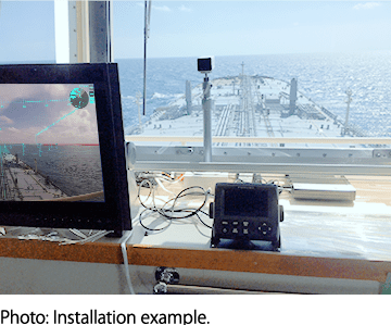
Interconnection Diagram
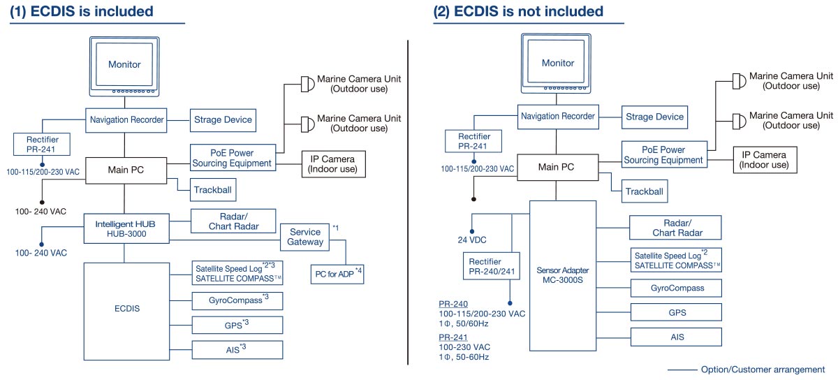
- Needed for displaying UKHO®ADP chart
- The level of pitch, roll and yaw compensation may vary depending on the performance and data conversion rate of the connected equipment.
- When 3 or more instruments are connected to the FMD-3100, the sensor adapter MC-3000S is required.
- Windows 10®, Microsoft NET Framework® v4.0, LAN pot, FURUNO CAST ADP software, UKHO® ADP software installation and a valid license are needed.
Compatible equipment
ECDIS
FM-3100*1, FMD-3200/3300*1, FMD-3005*1, FAR-3x00*3
Radar
FAR-14x7 series*2, FAR-15x8 series, FAR-2xx7 series, FAR-2xx8 series, FAR-20x8 MARK-2 series
Chart Radar
FAR-3000 series, FAR-3005 series
Satellite Compass™
SC-30, SC-33, SC-50, SC-70, SC-110, SC-130, SCX-21
Satelite Speed Log
GS-100
AIS
FA-30, FA-40, FA-50, FA-60, FA-70, FA-150, FA-170
GPS
GP-33, GP-39, GP-150, GP-170, GP-3500/3500F, GP-3700/3700F
- Route Sharing, ENC Chart Sharing and User Chart Sharing are available.
- The connection diagram (1) is not available for this series.
- Supported only when backup ECDIS is ON.
Drawing
- AIS is not included in the standard supply.
Certification

The AR navigation system has been certified as an
"Innovation Endorsement for Products & Solutions"
by ClassNK (Nippon Kaiji Kyokai) for its innovative technology.
Downloads
| Name | Last update |
|---|---|
| Jul 1, 2026 |
Distributors of Marine Equipment
Contact a local distributor for further details.
- Specifications subject to change without notice.
AR Navigation System Product List
There are no products that meet the conditions.
Support
Support for Legacy Products
Downloads
Furuno Marine Sensor SDK
Service Provision Scheme
Quality Assurance
Locate a Distributor
Contact
Support for Legacy Products
Downloads
Furuno Marine Sensor SDK
Quality Assurance
Locate a Distributor
Contact
Support for Legacy Products
Downloads
Furuno Marine Sensor SDK
Warranty Policy
Quality Assurance
Locate a Distributor
Contact
Support for Legacy Products
Downloads
Furuno Marine Sensor SDK
Quality Assurance
Locate a Distributor
Contact
Support for Legacy Products
Downloads
Furuno Marine Sensor SDK
Quality Assurance
Locate a Distributor
Navigation
Communication
Other Marine Equipment
Monitoring Solution
Maritime Training